| Formats | JPG, PDF, SVG, AI |
| Resolution | 300dpi |
| Dimensions | 300dpi: 5000 x 5000 px |
| Version | 1.2 |
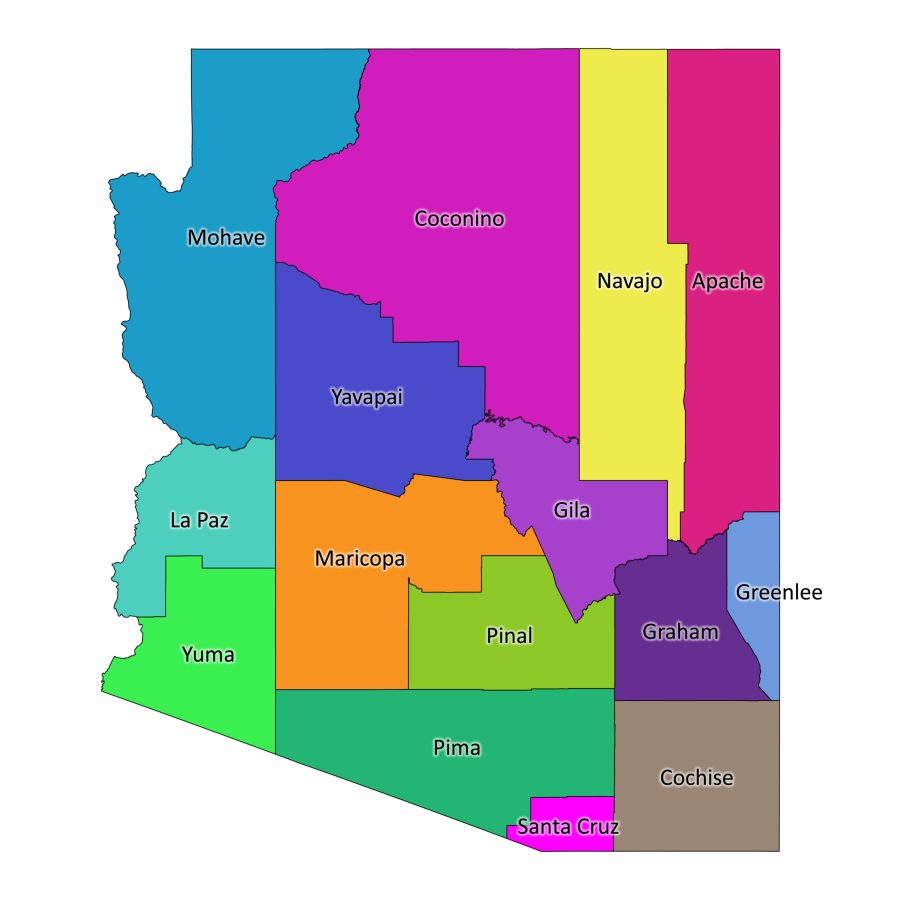
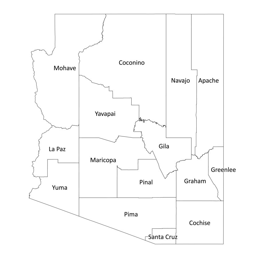
Unlock the essence of Arizona with our meticulously crafted Arizona labeled map. This digital product provides a detailed and labeled representation of all 15 counties in Arizona, catering to a diverse range of professional and educational uses. Whether you’re an educator, a researcher, or someone with a keen interest in geography, this downloadable map is a valuable addition to your digital library.
Features of Arizona labeled map
1. Comprehensive County Labels
Our Arizona labeled map features a detailed breakdown of all 15 counties in the state. From Apache to Yuma, each county is clearly labeled, providing an insightful overview of Arizona’s geographic diversity.
2. Black and White or Colored Versions
Customize your experience with the option to choose between a classic black and white map or a vibrant colored version. Tailor the map to your preference, ensuring it fits seamlessly into your professional presentations, reports, or educational materials.
3. Multiple File Formats
We understand the importance of versatility. That’s why our Arizona labeled map is available in PDF, JPG, SVG, and AI formats, bundled conveniently in a zip file. Whether you need a high-resolution image for printing or a scalable vector file for digital projects, we’ve got you covered.
Is the Labeled Map of Arizona Editable?
Our Arizona labeled map is designed to meet your customization needs. Here’s what you need to know about its editability:
- Editable AI Format: The AI (Adobe Illustrator) file included in the bundle provides full editability. You can modify labels, colors, and other elements to suit your specific requirements using design software like Adobe Illustrator.
- Customization in SVG Format: The SVG (Scalable Vector Graphics) format is widely supported and allows for customization using various vector graphic editors. Tailor the map to your liking while maintaining a high-quality resolution.
- PDF for Annotations: The PDF format is not only printable but also allows for annotations. You can add notes, highlights, or other annotations using PDF editing software.
How to Download Arizona Labeled Map
Downloading our Arizona labeled map is a seamless process, designed for your convenience. And the best part is you don’t need a user account.
- Visit our Website: Navigate to our user-friendly website.
- Add to Cart and Checkout: Confirm your selection and proceed to checkout.
- Download Your Map: Once the checkout process is complete, you’ll receive a link to download the bundled zip file containing your selected map in a zip file. You have access to unlimited downloads by just going to the download link within the order receipt
List of Counties in Arizona
Arizona boasts 15 counties, each contributing to the state’s unique cultural, historical, and geographical tapestry. Here is a list of Arizona counties:
- Apache
- Cochise
- Coconino
- Gila
- Graham
- Greenlee
- La Paz
- Maricopa
- Mohave
- Navajo
- Pima
- Pinal
- Santa Cruz
- Yavapai
- Yuma
Get to Know the State of Arizona
What is Arizona Known For?
Arizona is renowned for its diverse landscapes, rich Native American heritage, and vibrant cultural scene. The Grand Canyon, one of the Seven Natural Wonders of the World, stands as a testament to the state’s awe-inspiring geological features. Additionally, Arizona is famous for its desert landscapes, cactus-filled vistas, and the iconic saguaro cactus, which is synonymous with the American Southwest.
Arizona State Capital
Phoenix, the capital of Arizona, is a bustling metropolis nestled in the Salt River Valley. Known for its warm climate and vibrant urban culture, Phoenix serves as the political, economic, and cultural hub of the state.
Cities, Towns, and Villages
Beyond Phoenix, Arizona is home to a plethora of cities, towns, and villages, each with its unique charm and character. From the historic streets of Tucson to the scenic beauty of Sedona, every corner of Arizona has something special to offer.
Major Mountains and Valleys in Arizona
Arizona’s topography is defined by its majestic mountains and valleys. The state is home to significant geological features, including:
Mountains:
- Humphreys Peak: The highest point in Arizona, located in the San Francisco Peaks near Flagstaff.
- Superstition Mountains: Shrouded in mystery and folklore, these mountains east of Phoenix offer a rugged and picturesque landscape.
Valleys:
- Grand Canyon: While primarily known as a canyon, the Grand Canyon also features deep valleys that add to its breathtaking grandeur.
- Salt River Valley: Home to Phoenix and surrounding cities, this valley is a thriving urban center amidst the desert landscape.
Why Download Arizona Labeled Map?
Our Arizona labeled map goes beyond being a mere graphic representation. It serves as a valuable tool for educators, researchers, and professionals in need of accurate geographical data. Here’s why you should consider downloading our map:
- Educational Resource: Ideal for classrooms, our labeled map aids in teaching geography, history, and cultural studies.
- Professional Presentations: Enhance your presentations with a visually appealing and accurate map for business or academic purposes.
- Research and Analysis: Researchers can benefit from a comprehensive understanding of Arizona’s counties for various studies and analyses.
Don’t miss the opportunity to delve into the detailed geography of Arizona. Download our Arizona labeled map today and elevate your educational or professional projects with precision and accuracy.

Reviews
There are no reviews yet