Explore Trinidad and Tobago through our meticulously crafted map, which highlights the captivating first-level administrative regions of this Caribbean nation. Whether you’re an educator, researcher, or enthusiast, the labeled map of Trinidad and Tobago is a must-have addition to your resources, offering a comprehensive and accurate depiction of the country’s administrative landscape.
Trinidad and Tobago Labeled Map Features:
Detailed Administrative Labels
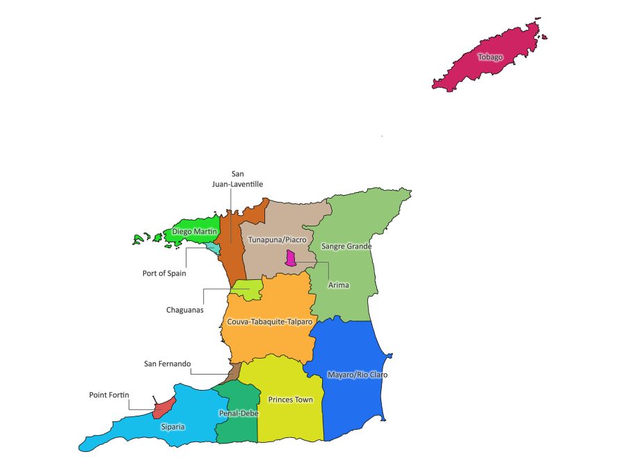
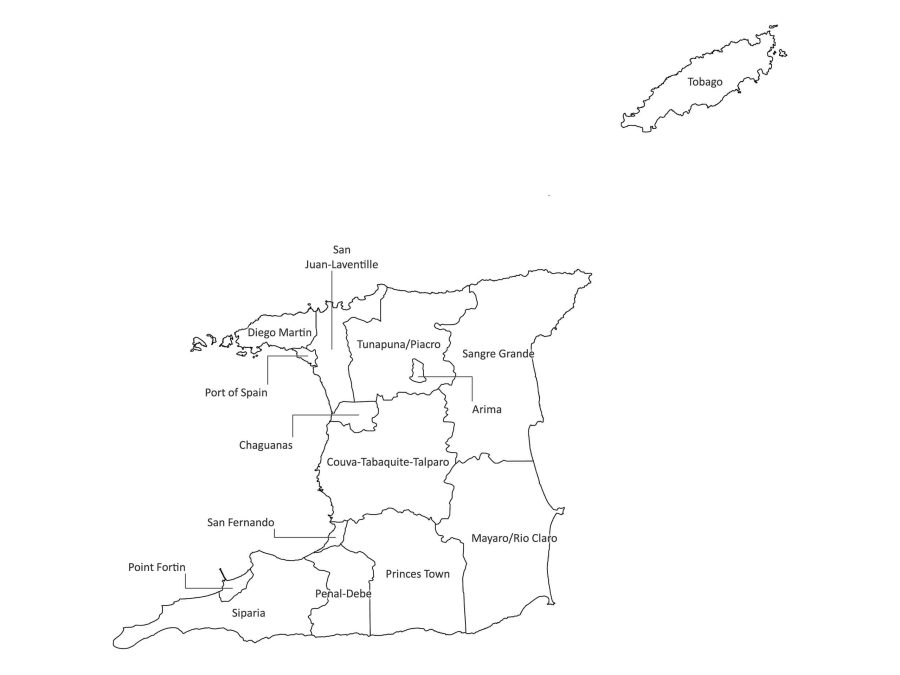
Our map meticulously outlines the first-level administrative divisions, providing a clear and detailed overview. Each administrative region, from Port of Spain to San Fernando, is accurately labeled, offering valuable insights into the country’s organizational structure.
Vibrant Color Palette
Experience the beauty of Trinidad and Tobago through our vibrant color palette. Each administrative division is distinguished by its color, creating a visually appealing and easily navigable map that adds an aesthetic touch to your presentations, reports, or educational materials.
Multiple File Formats
Versatility is key, and our map is available in various formats to meet your specific needs. Whether you prefer PDF for easy printing, JPG and PNG for digital use, SVG for scalable vector graphics, or AI for advanced customization, we’ve conveniently bundled them in a downloadable zip file.
How to Download the Labeled Map of Trinidad and Tobago
- Visit our Website: Navigate to our user-friendly website designed for seamless navigation.
- Add to Cart and Checkout: Add the labeled map to your cart by clicking on the buy button, and proceed to checkout.
- Download Your Map: Once the checkout process is complete, a link to download the bundled zip file containing your selected map in various formats will be provided.
Trinidad and Tobago Administrative Regions Overview
Trinidad and Tobago boasts diverse administrative regions, each contributing to the country’s cultural, historical, and economic tapestry.
List of Administrative Regions
Here is an overview of the first-level administrative divisions, encompassing boroughs, cities, and regions:
- Arima (Borough): Recognized for its Indigenous Peoples heritage, Arima, located in the east, hosts the annual Santa Rosa Festival.
- Chaguanas (Borough): A major commercial and residential hub in central Trinidad, known for its vibrant atmosphere.
- Couva-Tabaquite-Talparo (Region): An amalgamation of three distinct areas in central Trinidad contributing to the economic and cultural landscape.
- Diego Martin (Region): Known for scenic beauty, suburban lifestyle, and the Diego Martin River in the northwest.
- Mayaro/Rio Claro (Region): A coastal region in southeastern Trinidad, known for Mayaro Beach and its role in agriculture.
- Penal-Debe (Region): An important agricultural area in southwestern Trinidad, contributing to the nation’s food production.
- Point Fortin (Borough): A crucial borough in southwestern Trinidad, playing a significant role in the country’s energy sector.
- Port of Spain (City): The capital city, bustling urban center, known for lively culture, historic architecture, and vibrant Carnival celebrations.
- Princes Town (Region): Located in south-central Trinidad, known for agricultural activities and home to the Moruga Scorpion.
- San Fernando (City): A major city in southern Trinidad, recognized for economic significance, cultural contributions, and the annual La Divina Pastora procession.
- San Juan-Laventille (Region): Situated in northern Trinidad, encompassing a mix of urban and suburban areas, contributing to economic and cultural diversity.
- Sangre Grande (Region): Located in the northeast, a region with a mix of agricultural activities and natural attractions, including the Aripo Savannas.
- Siparia (Region): An agricultural hub in the south, boasting a rich history and cultural traditions, including the annual Siparia Fête.
- Tobago (Island): An autonomous island region known for serene beaches, lush landscapes, and vibrant cultural events, including the Tobago Jazz Festival.
- Tunapuna/Piarco (Region): In the north, known for economic activities, including the Piarco International Airport, contributing to the nation’s industrial landscape.
Why Choose Our Labeled Map?
Our labeled map of Trinidad and Tobago is more than a visual representation; it’s a valuable tool for various purposes:
- Educational Resource: Ideal for classrooms, helping students understand the administrative divisions of Trinidad and Tobago for geography and social studies.
- Professional Presentations: Enhance your presentations with a visually striking and accurate map for business or academic purposes.
- Research and Analysis: Researchers can benefit from a comprehensive understanding of Trinidad and Tobago’s administrative structure.
Trinidad and Tobago – Beyond the Map
Cultural Mosaic
Trinidad and Tobago’s cultural diversity is as vibrant as its administrative regions. The fusion of African, Indian, European, and Indigenous influences is evident in its music, dance, and festivals.
Carnival Extravaganza
Home to one of the world’s most renowned carnivals, Trinidad and Tobago’s Carnival is a spectacle of color, music, and revelry, attracting visitors from around the globe.
Natural Wonders
From the serene beaches of Tobago to the lush rainforests of Trinidad, the country is a haven for nature enthusiasts. Explore the Asa Wright Nature Centre or unwind on the picturesque Maracas Beach.
Economic Significance
Trinidad and Tobago’s strategic location and thriving energy sector contribute significantly to its economic strength. The Point Lisas Industrial Estate is a key player in the nation’s industrial landscape.
In Conclusion
Embark on a journey through Trinidad and Tobago’s administrative divisions with our map. Whether you’re a student, a professional, or someone eager to explore the cultural and geographical richness of this Caribbean gem, the labeled map of Trinidad and Tobago is an indispensable resource. Download our labeled map today and delve into the complexity of Trinidad and Tobago’s first-level administrative regions.

Reviews
There are no reviews yet.