| Formats | JPG, PDF, SVG, AI |
| Resolution | 300dpi |
| Dimensions | 300dpi: 5000 x 3750 px |
| Version | 1.2 |
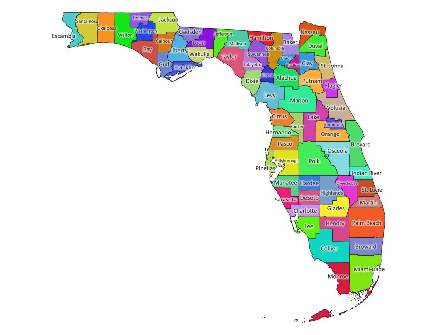
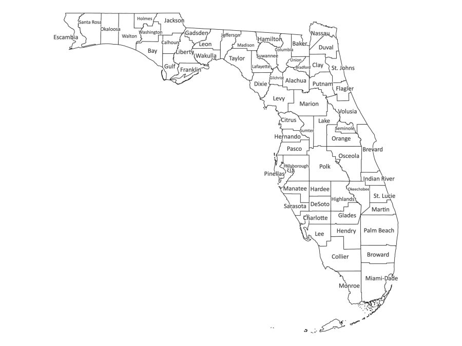
Explore Florida’s counties with a clear, ready-to-use Florida labeled map designed for classrooms, offices, and digital projects. Available in multiple formats and color styles, this downloadable map makes it easy to visualize and work with county-level information across the Sunshine State.
Key features of the Florida labeled map
Two visual styles
- Color version – Distinct county colors to help differentiate regions at a glance.
- Black & white version – Ideal for low-ink printing, photocopying, or use as a worksheet.
Included file formats
- PDF – Optimized for high-quality printing and presentations. Every label and boundary is sharp and easy to read.
- JPG – Great for websites, slides, and other digital uses where a standard image file is needed.
- SVG – Fully scalable vector format that can be resized without losing quality, perfect for web embedding and simple edits.
- AI (Adobe Illustrator) – Best for advanced editing, allowing you to customize colors, labels, and additional graphics.
All formats are bundled together in a single ZIP file for quick and convenient download.
What you get with this Florida map
Accurate county boundaries and labeling
Each of Florida’s 67 counties is clearly outlined and labeled, providing an accurate reference for geography, planning, and analysis.
Flexible color options
Use the colored version for visual presentations and the black & white version for worksheets, handouts, or minimalist design projects.
Ready for print and digital use
The map is suitable for both high-resolution printing and on-screen display, so you can use the same resource across multiple platforms.
Practical uses for your Florida map
In the classroom
Teachers and students can use the map for:
- Social studies and geography lessons
- County identification exercises
- Homework assignments and revision sheets
The clear labels make it easy for learners to quickly locate and remember each county.
For business and planning
Professionals can incorporate the map into:
- Market and territory analysis
- Sales and service region planning
- Internal reports and presentations
County boundaries help visualize where customers, offices, or service areas are located.
For publications and content
Bloggers, authors, and designers can use the map in:
- Articles and reports
- E-books and guides
- Infographics and marketing materials
Vector and image formats ensure you can keep the map sharp and on-brand.
Printing and editing the map
Printing the Florida county map
- Open the PDF file in Adobe Acrobat Reader (or similar software).
- Go to File → Print and confirm your paper size and orientation.
- Under page sizing, choose “Actual size” for true dimensions, or “Fit” if you prefer the map to fill the page.
- Select color or grayscale depending on your printer and needs.
- Print and check that labels and lines are clear and readable.
Editing the map
For customization, use the SVG or AI file:
- Open the file in a vector graphics program such as Adobe Illustrator or Inkscape.
- Select individual counties or labels to recolor, highlight, or annotate.
- Add your own legends, text, or icons as needed.
- Save a new version to keep both the original and your edited map.
Get to know Florida
Florida, known as the Sunshine State, is the 22nd largest U.S. state, covering about 65,755 square miles. It combines world-famous attractions such as Disney World with natural treasures like the Everglades. With its warm climate, long coastline, and diverse communities, Florida is a key hub for tourism, trade, and coastal living.
- State capital: Tallahassee
- Region: Southeastern United States
- Borders:
- Gulf of Mexico to the west
- Atlantic Ocean to the east
- Straits of Florida to the south
- Alabama (northwest) and Georgia (north)
Major cities include Jacksonville, Miami, Tampa, Orlando, St. Petersburg, Tallahassee, Fort Lauderdale, West Palm Beach, Naples, and Sarasota.
Florida counties (alphabetical list)
There are 67 counties in Florida, all clearly shown and labeled on the map:
Alachua, Baker, Bay, Bradford, Brevard, Broward, Calhoun, Charlotte, Citrus, Clay, Collier, Columbia, DeSoto, Dixie, Duval, Escambia, Flagler, Franklin, Gadsden, Gilchrist, Glades, Gulf, Hamilton, Hardee, Hendry, Hernando, Highlands, Hillsborough, Holmes, Indian River, Jackson, Jefferson, Lafayette, Lake, Lee, Leon, Levy, Liberty, Madison, Manatee, Marion, Martin, Miami-Dade, Monroe, Nassau, Okaloosa, Okeechobee, Orange, Osceola, Palm Beach, Pasco, Pinellas, Polk, Putnam, Santa Rosa, Sarasota, Seminole, St. Johns, St. Lucie, Sumter, Suwannee, Taylor, Union, Volusia, Wakulla, Walton, Washington.
Download the Florida labeled map to bring clarity to your lessons, projects, or planning work. With multiple formats, clear labeling, and easy customization, it’s a practical mapping resource for anyone working with Florida’s counties.

Reviews
There are no reviews yet