| Formats | JPG, PDF, SVG, AI |
| Resolution | 300dpi |
| Dimensions | 300dpi: 5000 x 3750 px |
| Version | 1.2 |
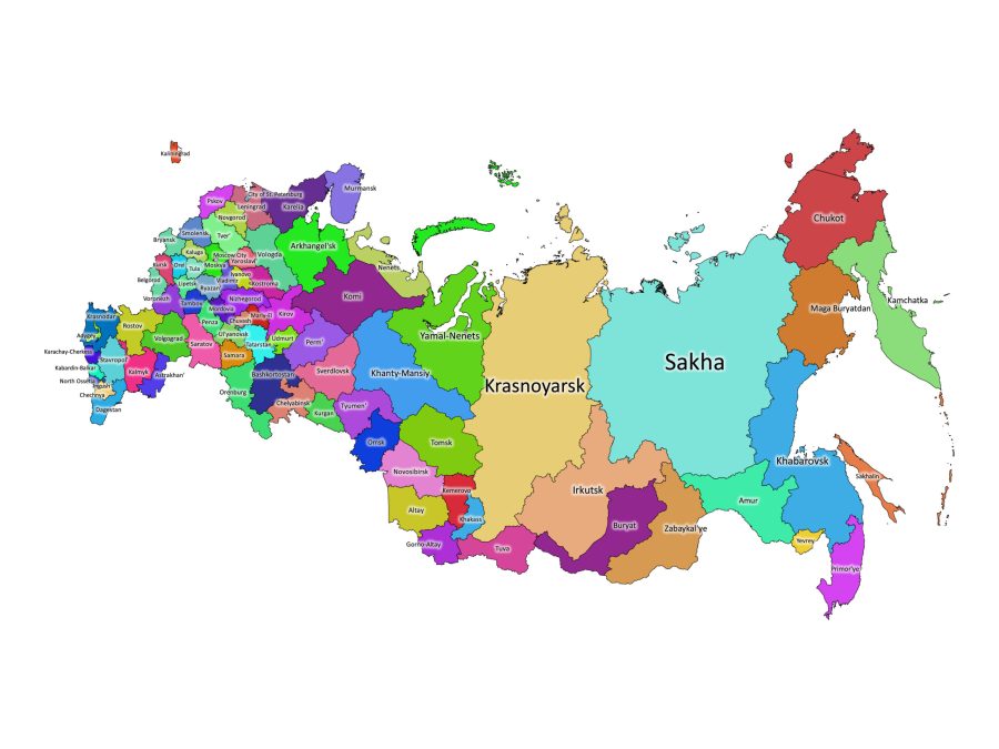
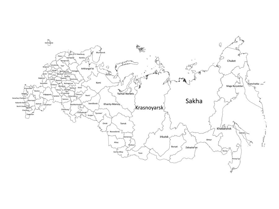
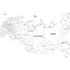
Are you looking for a detailed and accurate labeled map of Russia? Our digital product is the perfect solution! Our labeled map of Russia provides an easy-to-read and visually appealing representation of Russia’s federal subjects. Whether you’re a student, a teacher, or a designer, our map will provide you with what you need.
Features of the Labeled Map of Russia
- Available in Black and white and colored versions.
- Formats include PDF, JPG, SVG, and AI, all bundled in a zip file.
- Clearly labeled federal subjects for easy reference.
Is Russia labeled map editable?
Yes, our labeled map of Russia is editable, which means you can make changes to the map to suit your specific needs. The map is available in SVG and AI formats, which are vector file formats that allow for easy editing using software such as Adobe Illustrator or Inkscape.
Is Russia labeled map printable?
Yes, our labeled map of Russia is printable, and it is available in high-resolution PDF format. The high resolution of the map ensures that it will be clear and legible even when printed in larger sizes.
About Russia
What are Russia’s states called?
Russia is divided into federal subjects, not states. The country has 83 federal subjects. These federal subjects are divided into nine different categories, including 46 oblasts (provinces), 21 republics, nine krais (territories), four autonomous okrugs (districts), one autonomous oblast, and two federal cities. Our labeled map of Russia clearly shows each of these federal subjects and their labels, making it easy to understand the country’s complex administrative structure.
List of Federal Subjects in Russia
- Republic of Adygea
- Republic of Altai
- Altai Krai
- Amur Oblast
- Arkhangelsk Oblast
- Astrakhan Oblast
- Republic of Bashkortostan
- Belgorod Oblast
- Bryansk Oblast
- Republic of Buryatia
- Chechen Republic
- Chelyabinsk Oblast
- Chukotka Autonomous Okrug
- Chuvash Republic
- Irkutsk Oblast
- Ivanovo Oblast
- Jewish Autonomous Oblast
- Kabardino-Balkar Republic
- Kaliningrad Oblast
- Republic of Kalmykia
- Kaluga Oblast
- Kamchatka Krai
- Karachay-Cherkess Republic
- Republic of Karelia
- Kemerovo Oblast
- Khabarovsk Krai
- Republic of Khakassia
- Khanty-Mansi Autonomous Okrug – Yugra
- Kirov Oblast
- Komi Republic
- Kostroma Oblast
- Krasnodar Krai
- Krasnoyarsk Krai
- Kurgan Oblast
- Kursk Oblast
- Leningrad Oblast
- Lipetsk Oblast
- Magadan Oblast
- Republic of Mari El
- Republic of Mordovia
- Moscow
- Moscow Oblast
- Murmansk Oblast
- Nenets Autonomous Okrug
- Nizhny Novgorod Oblast
- North Ossetia–Alania Republic
- Novgorod Oblast
- Novosibirsk Oblast
- Omsk Oblast
- Orenburg Oblast
- Oryol Oblast
- Penza Oblast
- Perm Krai
- Primorsky Krai
- Pskov Oblast
- Rostov Oblast
- Ryazan Oblast
- Saint Petersburg
- Sakha Republic (Yakutia)
- Sakhalin Oblast
- Republic of North Ossetia–Alania
- Samara Oblast
- Saratov Oblast
- Republic of Tatarstan
- Smolensk Oblast
- Stavropol Krai
- Sverdlovsk Oblast
- Tambov Oblast
- Republic of Tatarstan
- Tomsk Oblast
- Tula Oblast
- Tuva Republic
- Tver Oblast
- Tyumen Oblast
- Udmurt Republic
- Ulyanovsk Oblast
- Vladimir Oblast
- Volgograd Oblast
- Vologda Oblast
- Voronezh Oblast
- Yamalo-Nenets Autonomous Okrug
- Yaroslavl Oblast
- Zabaykalsky Krai
The largest Federal Subject
The largest federal subject in Russia is the Sakha Republic, also known as Yakutia. This republic is located in the far eastern part of Russia and covers an area of over 3.1 million square kilometers. It is larger than India and comprises about 20% of the total land area of Russia. Despite its size, the population of Sakha Republic is relatively small, with only around one million people.
Countries neighboring Russia
Russia shares borders with 14 countries. These countries include Norway, Finland, Estonia, Latvia, Lithuania, Poland, Belarus, Ukraine, Georgia, Azerbaijan, Kazakhstan, Mongolia, China, and North Korea.
The population of Russia
Russia is the ninth most populous country in the world, with a population of approximately 144 million people. The majority of the population lives in urban areas, with Moscow being the most populous city. However, Russia’s population has been declining in recent years due to low birth rates and emigration.
Russia’s official language
The official language of Russia is Russian. It is spoken by the majority of the population and is also one of the six official languages of the United Nations. Russian is an East Slavic language and is closely related to Ukrainian and Belarusian.
Ethnic groups in Russia
Russia is a multi-ethnic country, with over 190 different ethnic groups. The largest ethnic group is Russian, which makes up around 80% of the population. Other significant ethnic groups include Tatars, Ukrainians, Bashkirs, Chuvash, Chechens, and Armenians.
Why download our Russia Labeled map
Downloading our labeled map of Russia comes with several benefits that make it an invaluable resource for a variety of purposes. Here’s why you should consider downloading our Russia labeled map:
- Precision and Detail: Meticulously crafted for accuracy, our map provides clear identification of Russia’s federal subjects.
- Educational Use: Ideal for students, teachers, and researchers, enhancing understanding in classrooms, presentations, and research projects.
- Professional Presentations: Adds a polished visual element for effective communication in professional reports, presentations, and articles.
- Customizable Formats: Editable in SVG and AI, allowing personalized adjustments such as labels, colors, and resizing.
- File Format Flexibility: Available in PDF, JPG, SVG, and AI formats for compatibility with various platforms.
- Printable Convenience: High-resolution formats (PDF, JPG 300dpi) enable easy printing for tangible references at home, print shops, or online services.
Reviews
There are no reviews yet