| Formats | JPG, PDF, SVG, AI |
| Resolution | 300dpi |
| Dimensions | 300dpi: 5000 x 3750 px |
| Version | 1.1 |
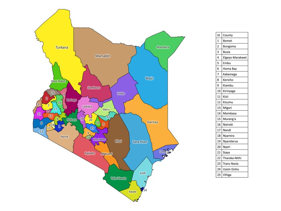
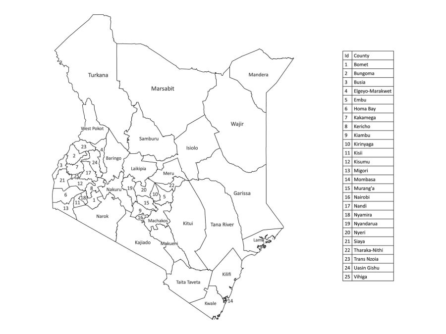
If you’re a geography enthusiast, student, or educator seeking an accurate depiction of Kenya’s administrative divisions, your search ends here with our Labeled Map of Kenya. This comprehensive map meticulously outlines all the 47 counties of Kenya, offering an indispensable resource for understanding the geographical intricacies of this captivating East African nation.
Features of the Labeled Map of Kenya
1. Detailed County Labels
Dive into the heart of Kenya’s administrative divisions with precision and clarity. Our labeled map meticulously outlines each county, offering a detailed representation that is indispensable for educational, business, and design purposes.
2. Dual Versions – Black and White or Colored
Tailor your experience to your preference. Choose the classic sophistication of the black and white version or revel in the vibrant hues of the colored map. Whichever you choose, the accuracy and clarity of the county labels remain unparalleled.
3. Multiple File Formats
Adapting to your diverse needs, our Labeled Map of Kenya is available in various file formats:
- PDF: Ideal for high-quality prints, presentations, and educational materials.
- JPG: Perfect for online use, quick reference, and seamless integration into digital platforms.
- SVG: Ensures scalability without compromising quality, making it a preferred choice for customization.
- AI (Adobe Illustrator): Tailor the map to your exact specifications with advanced editing capabilities.
Why Download Our Labeled Map?
1. Educational Insight
For students, educators, and researchers, our Labeled Map of Kenya serves as an indispensable educational tool. Uncover the nuances of Kenya’s county distribution, fostering a deeper understanding of the country’s geographical and administrative landscape.
2. Professional Reference
Professionals from various fields, including designers, can elevate their projects with our labeled map. Enhance presentations, reports, and design applications with a visually appealing and accurate representation of Kenya’s counties.
How to Download the Labeled Map of Kenya
Downloading our map is pretty easy and you don’t need an account to do that:
- Select file: Select your desired file format.
- Add to Cart: Click on the “Buy & download” button to initiate the download process. This should add the map to the cart and redirect you to the checkout.
- Secure Checkout: Follow the secure checkout process to complete your transaction. The download link will be available immediately after checkout.
About Kenya
Kenya is a lower-middle-income country located in Africa within the East African region. The country borders Ethiopia, Somalia, South Sudan, Tanzania, and Uganda, enhancing regional connectivity and cultural exchange in East Africa.
Kenya’s Diverse Counties
Kenya is divided into 47 counties, each with its own unique cultural, economic, and geographical characteristics. Explore the richness of Kenya’s regional diversity through our labeled map.
Listing of Counties
- Mombasa
- Kwale
- Kilifi
- Tana River
- Lamu
- Taita-Taveta
- Garissa
- Wajir
- Mandera
- Marsabit
- Isiolo
- Meru
- Tharaka-Nithi
- Embu
- Kitui
- Machakos
- Makueni
- Nyandarua
- Nyeri
- Kirinyaga
- Murang’a
- Kiambu
- Turkana
- West Pokot
- Samburu
- Trans-Nzoia
- Uasin Gishu
- Elgeyo-Marakwet
- Nandi
- Baringo
- Laikipia
- Nakuru
- Narok
- Kajiado
- Kericho
- Bomet
- Kakamega
- Vihiga
- Bungoma
- Busia
- Siaya
- Kisumu
- Homa Bay
- Migori
- Kisii
- Nyamira
- Nairobi (Capital City)
What is Kenya Known For?
The country of Kenya is renowned across the world for various things including:
Wildlife and Nature Reserves
- The Big Five: Kenya is globally renowned for being home to the majestic Big Five — lion, elephant, buffalo, leopard, and rhinoceros.
- Safari Destinations: Explore world-famous safari destinations such as the Maasai Mara, Amboseli National Park, and Tsavo National Park.
- Nairobi National Park: A unique feature of Kenya is Nairobi National Park, situated just outside the capital city. This park allows visitors to witness a variety of wildlife against the backdrop of the city skyline.
- Wildebeest Migration: Witness one of the most spectacular natural events – the Great Wildebeest Migration.
Rich Cultural Heritage
- The Maasai: Explore the cultural richness of the Maasai people, known for their distinctive customs, clothing, and traditional ceremonies.
- The 42 Tribes of Kenya: Kenya is a melting pot of diverse ethnicities, boasting 42 distinct tribes, each with its own languages, customs, and traditions.
Rift Valley
The Great Rift Valley, a geological wonder, is marked by several unique features that our labeled map can help you identify:
- Escarpments: The Rift Valley is flanked by impressive escarpments, offering breathtaking views of the landscapes below.
- Hot Springs: Discover geothermal wonders, including hot springs like those found in Lake Bogoria, where geysers shoot up from the earth’s crust.
- Lakes and Volcanoes: The Rift Valley is dotted with stunning lakes such as Lake Nakuru and Lake Naivasha, along with dormant volcanoes like Mount Longonot.
- The Valley Floor: Explore the vast valley floor, home to fertile farmlands, wildlife sanctuaries, and archaeological sites.
How to Print the Labeled Map of Kenya
If you need a physical copy of your Labeled Map of Kenya for professional reference, educational purposes, or decorative use, follow these simple steps:
- Download the PDF or JPEG(300dpi) and extract the downloaded zip file.
- Open the file in a compatible application (Adobe Reader for PDFs, any image viewer for JPEGs).
- Click on “File” in the menu bar.
- Select “Print” from the dropdown menu.
- Choose the printer you want to use.
- Adjust the printing settings as needed (e.g., number of copies, color, orientation).
- Click “Print” to start printing.
Download our Labeled map of Kenya today and explore the country’s diverse counties.


John Pierce –
Nice map with the major cities numbered. Received quickly and easily.