| Formats | JPG, PDF, SVG, AI |
| Resolution | 300dpi |
| Dimensions | 300dpi: 5000 x 3750 px |
| Version | 1.1 |
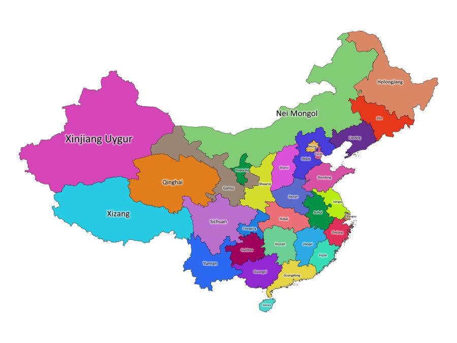
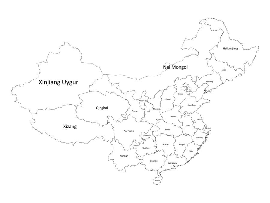
China is a vast country with a rich history, culture, and great people. Understanding China’s administrative divisions is crucial to anyone studying China’s geography. A labeled map of China is a useful resource that can help you identify the different provinces, autonomous regions, and municipalities.
Formats Available for our Labeled Map of China
The labeled map of China is available in different file formats, making it flexible and adaptable to different devices and preferences. Here are the different file formats available:
- PDF: The PDF format is ideal for printing the map on paper or viewing it on a computer.
- JPG: The JPG format is suitable for online use, including websites and social media platforms.
- SVG: The SVG format is suitable for editing the map in vector graphics software, including Adobe Illustrator and Inkscape. You can also embed the SVG into an HTML document.
- AI: The AI format is suitable for editing the map in Adobe Illustrator.
Is our labeled map of China vector-based?
Yes, our labeled map of China is available in SVG and AI formats, which are vector-based formats. Vector-based formats are ideal for maps because they are scalable and maintain their quality even when resized. They are also editable, which makes it easy to make changes to the map as needed.
In contrast, raster-based formats like JPG is not scalable and can become pixelated or blurry when resized, making it less suitable for maps that require high levels of detail.
About China
Where is China on the World Map?
China is located in eastern Asia and has the largest population in the world. It is bordered by 14 countries, including North Korea, Russia, India, and Vietnam, as well as the East China Sea, the Yellow Sea, and the South China Sea.
Different Administrative Divisions in China
China has 23 provinces, five autonomous regions, four municipalities, and two special administrative regions. Here is a list of China’s level one administrative divisions, specifying if it is a province, autonomous region, or municipality and including alternative names for the divisions:
Provinces:
- Anhui (安徽)
- Fujian (福建)
- Gansu (甘肃)
- Guangdong (广东)
- Guizhou (贵州)
- Hainan (海南)
- Hebei (河北)
- Heilongjiang (黑龙江)
- Henan (河南)
- Hubei (湖北)
- Hunan (湖南)
- Jiangsu (江苏)
- Jiangxi (江西)
- Jilin (吉林)
- Liaoning (辽宁)
- Qinghai (青海)
- Shaanxi (陕西)
- Shandong (山东)
- Shanxi (山西)
- Sichuan (四川)
- Yunnan (云南)
- Zhejiang (浙江)
Autonomous Regions:
- Guangxi (广西)
- Inner Mongolia (内
- Ningxia (宁夏)
- Tibet (西藏)
- Xinjiang (新疆)
Municipalities:
- Beijing (北京)
- Chongqing (重庆)
- Shanghai (上海)
- Tianjin (天津)
Special Administrative Regions:
- Hong Kong (香港)
- Macau (澳门)
Alternative Names for the Administrative Divisions
It is important to note that China’s administrative divisions have alternative names that are commonly used in different contexts. Here are some of the alternative names for China’s level-one administrative divisions:
- Beijing: Jing (京)
- Chongqing: Yu (渝)
- Fujian: Min (闽)
- Gansu: Long (陇)
- Guangdong: Yue (粤)
- Guangxi: Gui (桂)
- Guizhou: Qian (黔)
- Hainan: Qiong (琼)
- Hebei: Ji (冀)
- Heilongjiang: Hei (黑)
- Henan: Yu (豫)
- Hubei: E (鄂)
- Hunan: Xiang (湘)
- Inner Mongolia: Nei Mongol (内蒙古)
- Jiangsu: Su (苏)
- Jiangxi: Gan (赣)
- Jilin: Ji (吉)
- Liaoning: Liao (辽)
- Ningxia: Ning (宁)
- Qinghai: Qing (靑)
- Shaanxi: Qin (秦)
- Shandong: Lu (鲁)
- Shanxi: Jin (晋)
- Sichuan: Chuan (川)
- Xinjiang: Xin (新)
- Yunnan: Dian (滇)
- Zhejiang: Zhe (浙)
The Population of China
As of 2021, China has a population of approximately 1.4 billion people, making it the most populous country in the world. The country’s population is concentrated in its major cities, including Beijing, Shanghai, and Guangzhou.
The Size of China
China is the third-largest country in the world, covering approximately 9.6 million square kilometers. It has a diverse geography, including mountains, plateaus, deserts, and plains.

Reviews
There are no reviews yet